overview
An ice storm is defined as the accumulation of greater than ¼″ of freezing rain on solid surfaces like tree branches. A severe ice storm, capable of collapsing trees, is defined as the accumulation of greater than ¾″.
Likelihood
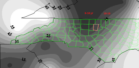
Unfortunately, we live near the center (roughly Greensboro) of an ice storm alley. The map below shows the average frequency for severely damaging ice storms for the 55-year period 1948–2003. Severely damaging ice storms (more than ¾″ freezing rain) like the ones in 2002 and 2014 occur here approximately every 10 years.
Average frequency for severely damaging ice storms (1948–2003)
 State Climate Office of NC A Winter Weather Climatology for the Southeastern United States
Recurrence intervals are denoted by gray bands.
Orange County is outlined in red.
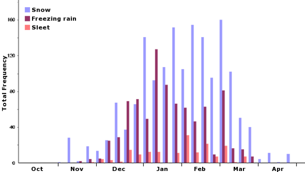 Greensboro: relative frequencies of snow, sleet & freezing rain
Winter climatology of North Carolina
Causation
Topography
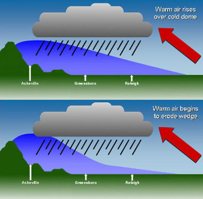
When a layer of warm air overlies a layer of cold air, the cold air, which is heavier, is trapped at ground level. In North Carolina, the trapped cold air cannot cross the Appalachian Mountains and instead simply collects, creating a wedge that is highest at the mountain edge. This is known as cold air damming.
Moisture
If the warm air contains moisture, areas under the wedge will experience snow, sleet, freezing rain or rain, depending on the depth of the cold air. Initial precipitation is often snow, sleet or a snow/sleet mix. As the warmer moist air erodes the cold air, the precipitation changes to freezing rain or rain.
Risk
The distance from the Appalachians determines the initial depth of the cold air layer and its susceptibility to erosion. In Orange County, conditions favor freezing rain, making ice storms likely. In contrast, Asheville’s deeper layer of cold air creates snow, while Raleigh’s shallower layer creates sleet.
 State Climate Office of NC Winter Weather: Patterns and Storm Types