Find your soil
You can learn about the soils and other features of your property using a mapping tool.
Orange County Interactive GIS
The Orange County Interactive GIS shows soils, floodplains, and other special features. It is faster and easier to use than the NRCS-USDA tool but shows only basic information. During busy times, the server will fail to load overlays such as soil series or contour lines.
NRCS-USDA
The NRCS-USDA Web Soil Survey is more complete but more complicated to use. Instructions are provided below:
The active tab should be AREA OF INTEREST.
- In the left panel, click ADDRESS.
- Type in an address or zipcode and click VIEW.
- In the right panel, use the zoom buttons at the top of the map if needed, then click an AOI button to define the area for which data will be mapped.
Click the SOIL MAP tab to see the soil types found in your AOI.
Click the SOIL DATA EXPLORER tab to learn about the features, uses, and limitations of your soil.
- Click the LEGEND tab at the top left of the right panel to add or change info other than soil type on the map.
NRCS Soil Extent
The NRCS Series Extent Explorer does not show your property. This is a dig-deeper tool that shows where else in the USA your soil series occurs. Check the boxes to make all of the layers visible. Note that you can also generate a map for any type of soil taxonomy by using the TAXONOMIC LEVEL tab. Click the OSD icon to learn more about the series and other similar soils.
Local soils
Ecoregions
Gardening can differ significantly between Orange, Durham, and Alamance counties, and also within Orange County, because of ecoregion differences. No major topographic changes occur in our area, so our ecoregions are dictated mainly by the underlying soil types.
Major soils
The chemical and mineral composition of a soil is determined primarily by the parent material — the unconsolidated rock from which a soil forms. Most of the soils of Orange County formed in residual material (the material that weathered from the underlying parent rock). Some of the soil differences, such as texture, color, or depth, are easily determined by observation.
As the map above illustrates, Orange County is divided into three subregions. The major soils for each subregion are bolded below and discussed in detail in subsequent sections.
Southeastern Orange County (subregion 45g)
Creedmoor, White Store, Iredell, Enon, Wilkes
The southeastern corner of the county is underlayed by Triassic sandstone, siltstone, and shale with injected intrusions of diabasic rocks.
- Creedmoor and White Store: Triassic parent materials
- Iredell, Enon, and Wilkes: residuum of diabasic intrusions
Central Orange County (subregion 45c)
Georgeville, Goldston, Herndon, Lignum, Orange, Tarrus_
Most of the central part of the county is underlain by volcanic rocks, mainly felsic and mafic volcanic slates.
Scattered pockets (subregion 45b)
Appling, Cecil, Helena, Louisburg, Vance, Wedowee
In several widely scattered areas in the northern, central, and southern parts of the county and south of the Triassic Basin, the parent materials are felsic crystalline rocks that are mostly granite, schist, and gneiss.
Floodplains
Altavista, Chewacla, Congaree
- Altavista: formed from old alluvium on stream terraces
- Chewacla and Congaree: formed from flood plains
All of the major soil types in Orange County have in common low organic matter content in the top layer and an acid–very acid subsoil. Once largely cultivated with crops such as cotton, corn, tobacco, and wheat, most of our soils are moderately to severely eroded. Even where not cultivated, erosion is a problem in our soils. For optimal plant growth and health, you should amend the soil with organic matter.
Trees common to the six major soils in our area include:
- Deciduous canopy: hickory, oak (white, black, northern red, southern red, crimson)
- Evergreen: loblolly pine
- Understory: dogwood, redbud, holly, sassafras
NW Orange County
About 25% of the county (the northwestern corner) is part of the Southern Outer Piedmont ecoregion (45b). This region consists of uplands of weathered granite and gneiss covered with deep saprolite and mostly red, clayey subsoils. It has lower elevations, less relief, and less precipitation than the Inner Piedmont and tends to have more cropland. Historically it was mainly cropland, with some woodland and pasture. Characteristics for the major upland soil types in this ecoregion are:
Appling sandy loam: 8.7% of county
This well drained soil is on broad ridges that are crossed by intermittent drainageways (areas generally elliptical in shape and 4–20 acres in size) or narrower side slopes that are crossed by intermittent drainageways (areas are long, narrow, roughly rectangular bands of 2–10 acres). Most of this soil is used as cropland, but some areas are used for hay and pasture or are forested.
| Solum Profile | surface 9″ subsurface 2″ subsoil 37″ |
|---|---|
| Permeability | moderate 0.6–2.0 inches/hour |
| Available water capacity | medium 0.1–0.15 inches water per inch soil depth |
| Subsoil | very strongly–strongly acid pH 4.5–5.5 |
| Depth to bedrock | greater than 60″ |
| High water table | below a depth of 72″ |
| Crops | High potential: horticultural crops like tomatoes, cucumbers, cantaloupes, sweet corn, green beans, peas Main limitations: slope, runoff, erosion |
| Trees | Dominant broad-leafed: tulip-poplar, sweetgum, hickory, ash, sycamore, oak (white, black, post, northern red, southern red, crimson) Dominant needle-leafed: pine (loblolly, shortleaf) Understory: mainly dogwood, sourwood, redbud, holly, black cherry, sassafras |
Helena sandy loam: 6.1% of county
This moderately well drained soil is on broad ridges (areas are generally elliptical in shape and are 4–30 acres in size). Most of this soil is in crops and pasture. Some is in trees.
| Solum Profile | surface 5″ subsurface 9″ subsoil 37″ |
|---|---|
| Permeability | slow 0.06–0.20 inches/hour |
| Available water capacity | low 0.10–0.12 inches water per inch soil depth |
| Subsoil | very strongly–strongly acid pH 4.5–5.5 |
| Depth to bedrock | greater than 48″ |
| High water table | normally below a depth of 60″, but because of the slowly permeable subsoil, a perched water table occurs at a depth of 12–30″ during wet seasons (Jan–Mar) |
| Crops | High potential: horticultural crops like tomatoes, cucumbers, cantaloupes, sweet corn, green beans, peas Main limitations: slope, wetness |
| Trees | Dominant broad-leafed: tulip-poplar, oak (white, black, post, northern red, southern red, crimson, blackjack, willow, chestnut), sweetgum, hickory, maple Dominant needle-leafed: cedar, pine (Virginia, loblolly, shortleaf) Understory: mainly dogwood, holly, sourwood, redbud, black cherry, sassafras Main limitations: wetness |
Central Orange County
Most of Orange County (72%) lies in the Carolina Slate Belt, ecoregion (45c). This region is an upland primarily of weathered slate with mineral-rich metavolcanic and metasedimentary rocks. Silty and silty clay soils, such as the Georgeville and Herndon series, are typical and contrast with soils of the Southern Outer Piedmont and Triassic Basin regions. Again, cropland was the major historic use, with significant pasture and woodland. Characteristics of the major upland soil types in this ecoregion are:
Georgeville silt loam: 32.1% of county
This well drained soil is on broad ridges (areas are generally elliptical in shape and are 5–100 acres or more in size) or narrow side slopes (areas are long, narrow, roughly rectangular bands 5–100 acres in size). Most of this soil is used as cropland, but some is used for pasture or woodland.
| Solum Profile | surface 7″ subsurface 0″ subsoil 65″ |
|---|---|
| Permeability | moderate 0.6–2.0 inches/hour |
| Available water capacity | high 0.15–0.20 inches water per inch soil depth |
| Subsoil | medium–very strongly acid pH 4.5–6.0 |
| Depth to bedrock | greater than 60″ |
| High water table | below a depth of 72″ |
| Crops | Main limitations: slope, runoff, erosion, permeability |
| Trees | Dominant broad-leafed: oak (white, black, post, northern red, southern red, crimson, chestnut), tulip-poplar, sweetgum, hickory, maple, beech, ash Dominant needle-leafed: loblolly pine Understory: mainly dogwood, sourwood, redbud, holly, black cherry, sassafras |
Tarrus silt loam: 9.5% of county
This well drained soil is from parent material similar to Georgeville, but has less defined layers and thinner surface and subsoil layers due to its formation on sloping to moderately steep slopes: 8–15% incline (areas are generally elliptical in shape and are 5–20 acres in size) or 15–25% incline (areas are long, narrow, roughly rectangular bands of 2–25 acres in size). Most of this soil is in woodland and pasture with some of the gentler slopes in crops.
| Solum Profile | surface 5″ subsurface 0″ subsoil 29″ |
|---|---|
| Permeability | moderate 0.6–2.0 inches/hour |
| Available water capacity | low 0.14–0.20 inches water per inch soil depth |
| Subsoil | very strongly–strongly acid pH 4.5–5.5 |
| Depth to bedrock | 40–60″ |
| High water table | 48–72″ |
| Crops | Main limitations: slope, runoff, erosion, permeability |
| Trees | Dominant broad-leafed: oak (white, black, post, northern red, southern red, crimson), tulip-poplar, hickory, maple, beech Dominant needle-leafed: pine (loblolly, Virginia, shortleaf) Understory: mainly dogwood, redbud, holly, sassafras Main limitations: wetness |
Herndon silt loam: 16.2% of county
This well drained soil is on broad ridges (areas are generally elliptical in shape and are 4–50 acres in size) or narrow side slopes (areas are long, narrow, roughly rectangular bands of 5–50 acres in size). Most of this soil is in crops with some in pasture and woodland.
| Solum Profile | surface 4″ subsurface 5″ subsoil 49″ |
|---|---|
| Permeability | moderate 0.6–2.0 inches/hour |
| Available water capacity | high 0.14–0.20 inches water per inch soil depth |
| Subsoil | strongly–very strongly acid pH 4.5–5.5 |
| Depth to bedrock | greater than 60″ |
| High water table | below a depth of 72″ |
| Crops | Main limitations: slope, runoff, erosion, permeability |
| Trees | Dominant broad-leafed: oak (white, black, post, northern red, southern red, crimson), tulip-poplar, sweetgum, hickory, maple, ash, beech Dominant needle-leafed: pine (loblolly, shortleaf, Virginia) Understory: mainly dogwood, sourwood, holly, redbud, sassafras |
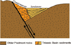
Southeast Orange County
The southeastern corner (about 2% of Orange county) lies in one of the four Triassic Basins (Ecoregion 45g) of North Carolina. Triassic basins formed when large blocks of the earth’s crust fractured and then subsided, creating deep rifts that then filled in with river sediments. The Triassic Basins have an unusual geology of unmetamorphosed shales, sandstones, mudstones, siltstones, and conglomerates:
 JW Clay, PD Escott, DM Orr Jr, AW Stuart Land of the South
Local relief and elevations are often less than in surrounding regions and, because the parent rocks are easier to erode, stream valleys that cross the region tend to widen. Soils are often clayey with low permeability, and streams have low base flows. The clay has a high shrink-swell potential that can hinder construction; it is also utilized by many brick makers in the region. A mosaic of mixed and deciduous forest, pasture, cropland, and urban land cover occurs here. In the wider floodplains, large bottomland hardwood forests occurred before they were covered by the water of reservoirs such as Jordan Lake, Falls Lake, and Harris Reservoir. The major soil type in this region is White Store.
White Store loam, clay loam: 1.5% of county
This moderately well drained soil is on broad ridges (areas are generally elliptical in shape and are 2–10 acres in size) or narrower side slopes (areas are roughly rectangular and are 2–25 acres in size). Most of this soil is used as woodland, but small areas are used for crops, hay, and pasture.
| Solum Profile | surface 5″ subsurface 0″ subsoil 29″ |
|---|---|
| Permeability | very slow < 0.06 inches/hour |
| Available water capacity | low 0.14–0.16 inches water per inch soil depth |
| Subsoil | strongly–very strongly acid pH 4.5–5.5 |
| Depth to bedrock | 48–72″ |
| High water table | below a depth of 36 inches, but a perched water table is 6–18 inches below the surface in places during wet periods (Dec–Mar) |
| Crops | Main limitations: slope, runoff, erosion, permeability, wetness |
| Trees | Dominant broad-leafed: maple, oak (blackjack, white, black, northern red, southern red, crimson, willow), hickory, sweetgum Dominant needle-leafed: cedar, pine (loblolly, shortleaf, Virginia) Understory: mainly dogwood, redbud, sourwood, holly, black cherry, sassafras Main limitations: clayey subsoil |
resources
NC gap analysis project
The NC gap analysis project maps native terrestrial vertebrate species distributions, natural landcover, land stewardship, and conservation status.
NC wildlife resources commission
The commission divides the state into 23 distinct habitats, eight of which belong to the Piedmont, and has created a concise association matrix listing priority birds, mammals, amphibians, and reptiles for each habitat.
Carolina vegetation survey
The Carolina Vegetation Survey is an exciting collaborative research program to document the composition and status of vegetation native to the Carolinas. Scientists from universities (UNC Chapel Hill, NC State, SC CES, Western Carolina, The Citadel), organizations (NC Botanical Garden, NC Natural Heritage Program, Nature Conservancy, NatureServe), and the Plant Protection Program of the NC Department of Agriculture have partnered to create a dynamic online tool that lets you find habitats by name or key species and provides Google maps of their locations.
The Piedmont section main classes are upland forests, open upland, alluvial wetland, and nonalluvial wetland. Numerous subdivisions are then available, each listing key species. The tool is organized hierarchically to make it very concise and easy to use. Links are provided to the corresponding NatureServe page. The Carolina Vegetation Survey is much easier to use than NatureServe itself. As an example, the Piedmont Open Upland class includes the subsets below, which are then further divided:
- woodlands & glades
- shrubby woodlands
- poorly-drained woodlands
- rock outcrop vegetation
- cultural / successional / exotic upland open vegetation
Name That Plant
NameThatPlant started as the 40-hour volunteer commitment of a South Carolina Master Gardener. The site is a clearinghouse of information about native and naturalized plants of the Carolinas and Georgia, including plants found throughout the Southeast. It is designed for use by the general public as well as botanists. You can search for a particular plant and see a distribution map, but the real strength of the site is the Plant Communities section. Different types of communities are described in non-technical terms. Typical overstory and understory plants are listed, then plants that are distinctive to the community or unique to the community.
Links
- Orange County Soil Survey
- Ecoregions map
nice especially for the range maps of NC natives - Southeastern Mixed Forests Ecoregion
includes lists of flora in forest subtypes - Land cover trends in the Piedmont
conservation status of native terrestrial vertebrates & natural land cover types - NC Vegetation — Habitats
- Guide to the Natural Communities of North Carolina, 4th Approximation
the reference standard, native & naturalized plants, distribution maps, especially valuable for descriptions of plant communties - NC Natural Heritage Program
- Habitat Association Matrix
- NC Native Plant Society — Conservation
- Inventory of important natural areas & wildlife habitats in OC\